Welcome to Dartmoor Buckfastleigh Walk
Route Details
Terrain: Largely on roads, with the occasional easy going to moderate off road sections. The walk does include a long stairway.
Time: approx. 3 ½ hours
Distance: 5.8km (3.6 miles) or shorter route 2km (1.2miles)
Facilities: Toilets in car park
Parking: Victoria Woodholme car park (pay and display)
Summary: This walk takes you through the historic town of Buckfastleigh and the abbey village of Buckfast. Buckfastleigh developed as two distinct settlements: higher and lower town, the two towns were linked for the first time in the 19th Century during a time of great building. Discover some of the interesting features of the area and stop off in one of the coffee shops or pubs for refreshments once you’ve finished your walk.
Download routeTo start the walk turn right out of the car park and follow the pavement to the town centre.
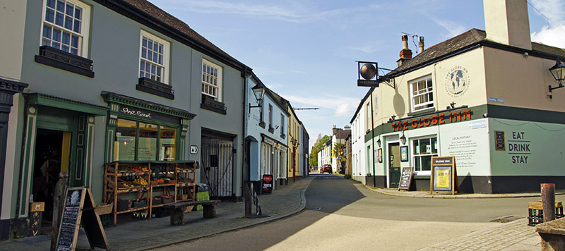
1. Medieval high street
At the Globe Inn, turn right and walk down the high street into Buckfastleigh Lower Town. The high street has a medieval layout made up of long thin properties called burgage plots, each giving access to the River Mardle and Dean Burn. These are land divisions of medieval date, representing plots of land rented out by the lord of Buckfastleigh. The courtyards and workshops of each property are accessed through arches known locally as Opways, each with their own character. Along the high street look out for The Valiant Soldier, an active town pub until the 1960s, it is now a museum giving people a glimpse of times gone by.
Continue down the high street and follow the road round to your left following the sign posts for the steam railway.
2. Step back in time
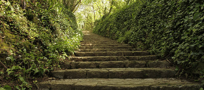
Follow the road as it bears left, crossing over the bridge which dates to 1749. Immediately after the row of houses on your left, take the steps up the hill signed public footpath. These steps lead to the Holy Trinity Church and are thought to have been built in the 19th century. Take the steps, as you walk up them look out for the Kissing Steps. The stones of these two steps are set in the opposite direction to the others and it is said that a wish made on these steps will come true. Continue to the top of the steps, through a kissing gate and up the track ahead of you. At the top of the track you will come to a turning circle and Holy Trinity Church.
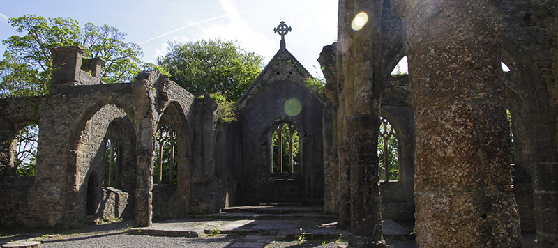
3. Ruined Churches and Hidden Caves
The 13th century Holy Trinity Church was burned down in July 1992, all that remains today are its shell and the spire that was added in the 1840s. Excavation has revealed that it was likely the site of a monastic community preceding that of Buckfast Abbey and is probably of early Christian origin. The bells were restored following the fire and, despite the damage, services are still held here.
Buckfastleigh is home to an extensive cave system. In the field opposite the church you can see one of the entrances to the system. The William Pengelly Cave Studies centre look after the limestone caves. The remains of straight-tusked elephants, hyena and hippopotamus from the last interglacial period have been found in them. They are also home to a colony of Greater Horseshoe Bats.
After exploring the church, walk down the road that leads from the church until you reach a road junction. Here you have the option to take a short route back to the village. For the long route, at the junction take the footpath on your right through the kissing gate. Make your way across the fields and along an old track to the main road where Buckfast Abbey will come into view.
For a shorter route back to Buckfastleigh, take the left hand turn onto Church Hill Lane. Go down the hill where the lane will narrow to a pathway that joins Holne Road. After leaving the pathway cross over the road and turn left. Follow the pavement immediately to the next junction, turn right and follow the road which bears left and takes you back to the high street.
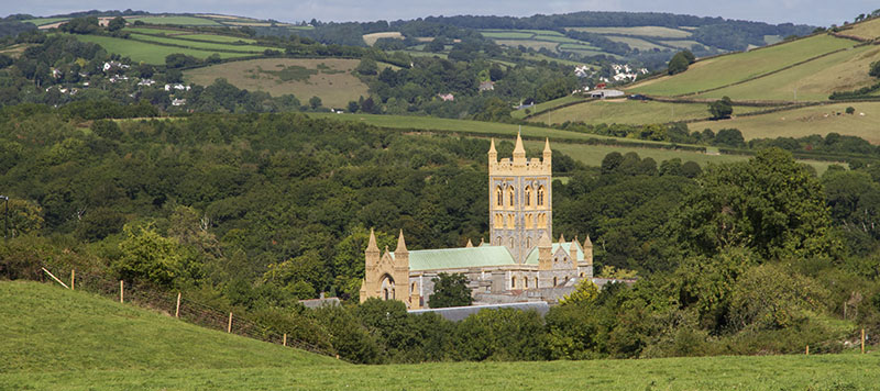
4. Buckfast Abbey
At the main road you will be able to catch glimpses of Buckfast Abbey. Follow the pavement around to your left and up the hill, passing the entrance to the Abbey. This establishment was founded in 1018 by Aethelweard, the King’s officer in Southwest England. The Abbey flourished for over 500 years until its dissolution by Henry VIII in 1539. Over the following three centuries, the Abbey remained in private hands until it was re-founded by a group of Benedictine monks from France in 1882. At the school, take a sharp right onto Higher Mill Lane and follow the road until you reach a sign for Grange Road. At the junction, follow the road to your left along Grange Road and continue along this road for a while until you come to the T junction. At the junction, turn left and follow the road up the hill until you reach another junction.
At the next T junction take the footpath straight across the road, walking downhill along the track, where the path splits keep left and continue downhill (the path will split again, again keep left) and follow the track, the river will appear on your right hand side. Follow the path until you reach the road, turn left and follow the road.
5. Higher Town
As you walk along the road, you will pass defining features of the town’s industrial past. The Tannery is the oldest working sheepskin tannery in the UK. Tanning has taken place in Buckfastleigh since at least the 16th century. In 1806, the Hamlyn family bought the Tannery and created an empire in the town, becoming one of the most important employers; building houses for themselves and workers and aiding the Methodist Church, schools and helping to build the town hall and public parks.
The Grade II* row of weavers cottages with tenter lofts on Chapel Street are survivors of the industrial history of Buckfastleigh. The tenter loft is a rare survival in Devon, used for drying cloth slowly, stretched on tenterhooks, with louvres that could be adjusted according to the weather.