Open access and rights of way
Public Rights of Way
One of the things that makes Dartmoor so special is the open access to the commons where you can walk freely rather than sticking to footpaths. But there are also hundreds of miles of paths and tracks which you can use. These include around 730 km (449 miles) of public rights of way (footpaths, bridleways and byways) as well as other paths and tracks where the owner allows access.
Public Footpaths
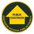 You may walk (and take a pram, pushchair or wheelchair where practical). You can take a dog, but you must keep it under close control.
On Ordnance Survey Explorer maps, public footpaths are shown by short green dashed lines. They may also be signposted and waymarked with yellow arrows or yellow paint spots.
Public Bridleways
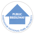 You have the same rights as on a footpath but also you can ride a horse or a bicycle (cyclists should give way to walkers and horseriders).
On Ordnance Survey Explorer maps, public bridleways are shown by long green dashed lines. They may be waymarked on the ground with blue arrows or blue paint spots.
Byways Open To All Traffic
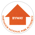 On a byway you have the same rights as on a footpath or bridleway but also you can drive a horse and carriage and drive a motor vehicle where practical (given that these are unsurfaced highways and may be at risk of erosion and damage). Byways are the only rights of way of way where it is legal to take a motor vehicle so you should always check that a route is a legal byway.
On Ordnance Survey Explorer maps, byways are marked by green crosses. They will be signposted as a byway at the start of the route.
Permissive Paths
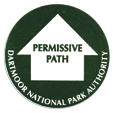 As well as footpaths and bridleways which you have a legal right to use, Dartmoor has many miles of other routes, known as permissive paths, which the landowner allows you to use. On Ordnance Survey Explorer maps, permitted routes are sometimes shown by orange lines (short dashes for footpaths and long dashes for bridleways). Not all permitted routes are shown on the maps. You should also look out for signposts at the start of routes and waymarkers along the route.
Other Routes with Public Access
In addition to public rights of way and permissive paths, there are other tracks where access is allowed. Some of these are shown on Explorer maps with green dots. These will always be routes where you can go on foot, but access on horse or by bicycle may vary.
Where can I find out more information?
Ordnance Survey maps show rights of way and many permissive paths. The Outdoor Leisure Map (OL 28) covers most of Dartmoor National Park and is available from National Park Visitor Centres.
If you want to know where to cycle try the 'Dartmoor for On and Off Road Cyclists Map' available from our Visitor Centres.
Access Land
One of the special qualities of Dartmoor National Park is the freedom to roam across 47,000 hectares of unenclosed common land and open country. On the open moor you are free to choose your own walking route and there is no need to keep to footpaths.
Dartmoor Commons – for walkers and horse riders
Open access on foot and horseback to 35,200 hectares of common land was made a legal right under the Dartmoor Commons Act (1985). This covers much of the existing open moorland in the National Park. Please follow the Dartmoor National Park Byelaws when visiting the Dartmoor Commons. Copies of the Byelaws are available from local Information Centres; or view them on-line: Dartmoor National Park Byelaws.
Countryside and Rights of Way (CRoW) Act – for walkers
Since August 2005, the CRoW Act has given a new right of open access to ‘open country’ and registered common land. However, on Dartmoor the common land already has open access under the Dartmoor Commons Act so this part of CRoW Act does not apply here. The right of access on foot under the CROW Act applies to approximately 7,000 hectares of ‘open country’,
More details about the CRoW Act can be found on the Defra website
Making changes to the path network
A right of way which appears on the Definitive Map is legally protected and cannot be diverted or closed without a legal process involving making a Public Path Order.
Temporary Closures
It is possible to temporarily close a right of way for works to be undertaken by means of a Traffic Regulation Order. Fees and charges apply.
Temporary Traffic Regulation Order - Application Form
Temporary Traffic Regulation Order - Information for Applications
Temporary closures and other Access and Rights of Way notices can be found on the Access and Rights of Way notices page.
Diversion and Extinguishments
Landowners may apply to the Authority for a permanent diversion of a right of way across their land. If this is something you are considering, please contact your sector Ranger for an initial discussion or email recreation@dartmoor.gov.uk
Report a Path Problem
Due to the Covid-19 pandemic and restrictions on movement, Dartmoor National Park Authority's Access and Ranger Teams are giving priority to reported problems on the public rights of way network which present a safety hazard for the public. We will continue to carry out work on the network that is deemed necessary to keep the paths open and safe to use. Issues of a lower priority can still be reported but are unlikely be progressed in the usual timescale. Your patience in these difficult times is appreciated.